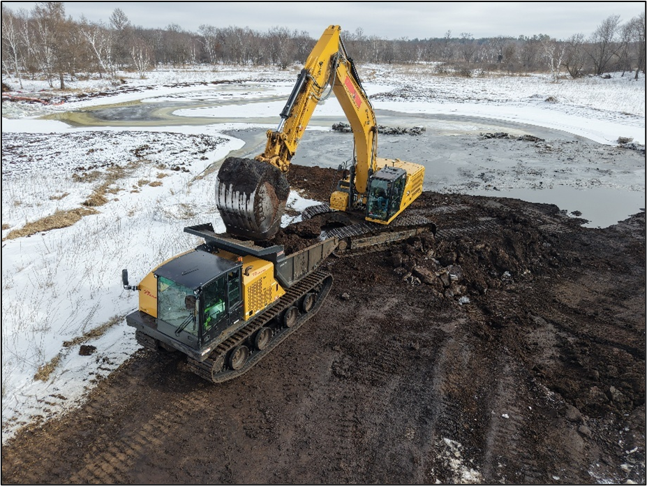
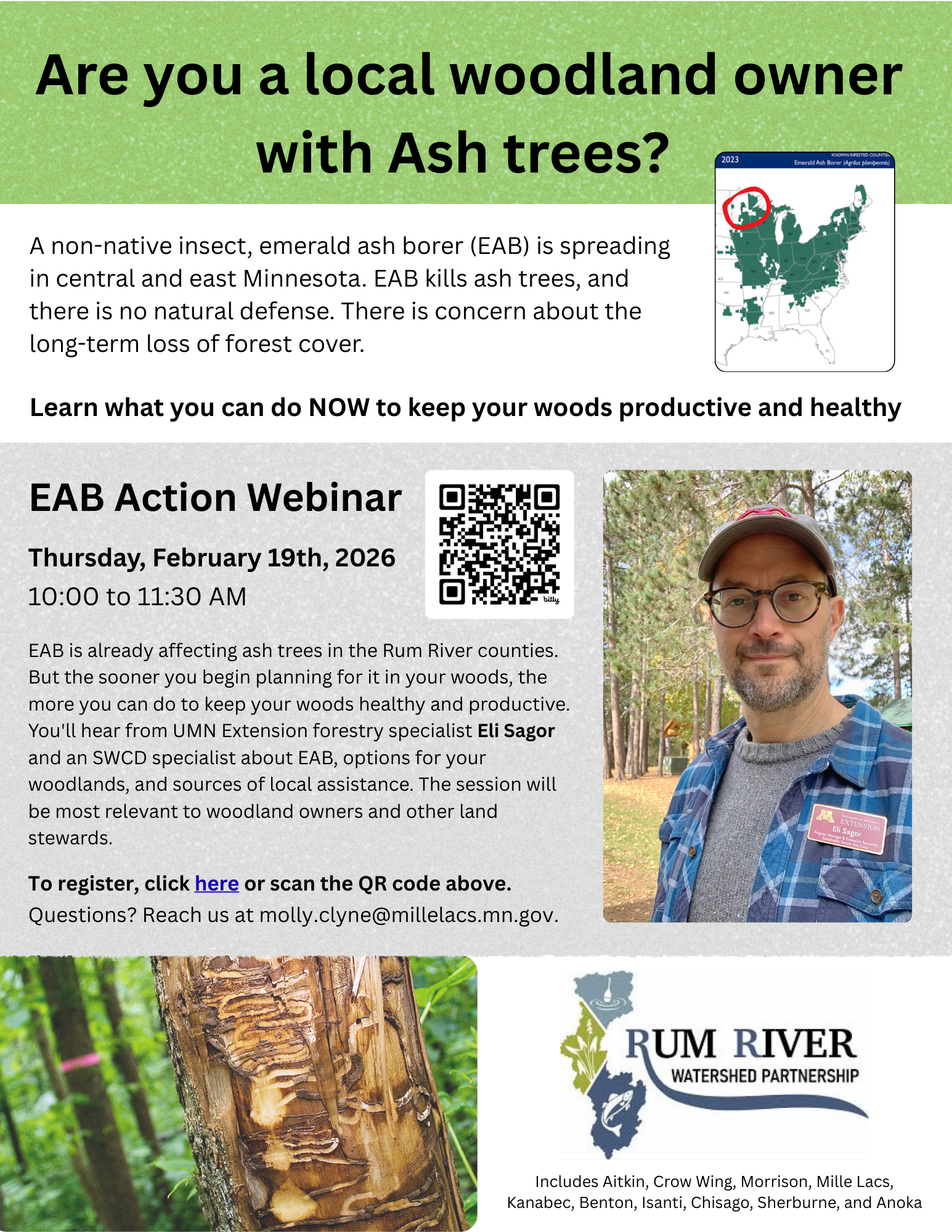
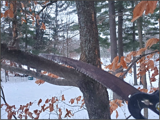
Well Sealing Funding Extended Through 2024!

Unused wells can serve as direct conduits for surface contaminants to reach our aquifers. ACD was awarded a grant in 2020 through the Clean Water Fund to help eligible landowners seal unused wells located within Anoka County. This program has been extended to run through 2024 in order to continue to to provide local residents assistance with sealing an unused well on their property!

A well is defined as "not in use," when the well is not functional, cannot readily pump water, or has not been operated on a regular basis. A "not in use" well has not been sealed by a licensed well contractor. A well that is "not in use" (i.e., "abandoned") must be repaired and put back into use, permanently sealed by a licensed well contractor, or the owner must obtain a maintenance permit. In many cases, placing an old well back into use is not practical. Sealing your well is also legally required when you go to sell your home. If your house was built before public water was available, the property may have one or more wells. Wells can be located either inside or outside a residence. 

Indoors look for:

  • Glass block or concrete patch in an exterior step.
  • Wells are often housed in a small room in the basement, many times under exterior concrete steps.
  • Pipe sticking up out of the floor in your basement, or a concrete patch in the floor where the well was located. 
Outdoors look for:
  • Low spot or sunken area in the ground.
  • Metal, wood, or concrete cover or manhole.
  • Areas that stay wet can be caused by an unsealed flowing well.
  • An old shed or well house, or an old pump.
  • Dug wells typically appear as a ring anywhere from 1 foot or several feet in diameter, made of concrete, tile, bricks, or rocks.
  • Pipes above, at, or below the surface may indicate a well.

Visit ACD's website today to get more information or to download an application to apply. If you are unsure if you have a well on your property or questioning if you would qualify for funding simply contact Kris Larson, This email address is being protected from spambots. You need JavaScript enabled to view it.
  455 Hits

Staying Active in the Winter

"What good is the warmth of summer, without the cold of winter to give it sweetness?" wrote John Steinbeck. We know that Minnesota winters ban be frigid, making people more likely to stay indoors. Many residents are unaware of all the great activities are out there to keep you from becoming stagnant in the winter months and able to stay healthy and happy. Sometimes winter activities are even more exciting and offer experiences that you don't get during other seasons. Cold-weather camping is a great way to savor those special moments but many folks, even experienced campers, think the idea sounds crazy. Click here to learn more about the basics of winter camping from the Sierra Club.

To help Minnesotans plan winter visits to state parks, and other recreational areas, the Minnesota DNR shares its top tips to have fun this winter, along with other resources for planning a winter adventure. "We know Minnesotans love being outdoors, and winter offers a whole new way to play outside," said Ann Pierce, the DNR's Parks and Trails Division director. "However, we also know cost and information can be barriers for Minnesotans to get outdoors and enjoy nature. We're working to alleviate this for folks by providing no cost or low-cost activities and providing easy trip planning resources."

  471 Hits

Winter Work is Underway!

Believe it or not, winter is a busy time of year for ACD's field crew. This winter, our buckthorn crew has started a five-year restoration project at Lamprey Pass Wildlife Management Area (WMA) in Columbus, MN. A popular destination for waterfowl hunting, Lamprey Pass is the second largest WMA in the North Metro. 

Buckthorn thicket after clearing
Buckthorn thicket before clearing
ACD Technicians next to a huge Common Buckthorn 

The Lamprey Pass site is currently overrun with common buckthorn, a large invasive shrub that crowds woodland understories and shades out native plants. ACD's crew is working hard to remove this invasive plant from the WMA, creating a more open habitat which will benefit native plant species and make the woodlands more hospitable for hunters. The images above and below demonstrate the impact of clearing buckthorn on the site. For more information about treating buckthorn, contact Logan Olson, Restoration Technician at Logan.Olson @AnokaSWCD.org 

  294 Hits

AI Helps Tell Anoka County's Groundwater Story

I've been dabbling with how to leverage artificial intelligence (AI) to improve productivity at ACD. Using ChatGPT, I've found a tool that can help generate an outline to serve as a jumping off point when starting a report or project plan. Recently, groundwater contamination problems have been popping up in the news. Within two Andover neighborhoods, residents with contaminated private wells are reduced to only using bottled water until they can hook up to city water. The plume of contamination below their homes, now plaguing them, will certainly continue its journey, ominously passing under neighborhoods in its path. Those hooked up to city water supplies will be fine. Those on wells, may be in for an unsettling surprise.

Where does AI come in? I asked ChatGPT to write a short somber poem about groundwater pollution. Here you go…


Beneath the soil, where secrets flow,
Groundwater whispers, tainted below.
Pollution seeps, a silent intrusion,
Nature's tears in liquid confusion.
Once pure, now stained with human's trace,
A solemn grave for life's embrace.
Quietly it suffers, unseen and still,
Groundwater mourns, a poisoned rill.


Contact Chris Lord, District Manager, at This email address is being protected from spambots. You need JavaScript enabled to view it. 

  667 Hits

Hundreds of Project Opportunities Near the Rum & Mississippi Rivers

Stormwater runoff from human-modified landscapes is a source of excess water and pollutants that can significantly impact rivers, lakes, and wetlands on the receiving end. However, not all drainage areas are created equally; rural landscapes with abundant agriculture and artificial drainage features, or urban areas with infrastructure predating stormwater treatment regulations, are often the most impactful. Areas draining to a priority waterbody are targeted for Subwatershed and Stormwater Retrofit Analyses (SRAs and SWAs). In these analyses, we study how runoff is moving through the landscape, strategically place various Best Management Practices (BMP's), and estimate their anticipated water quality benefits and installation costs. These findings are then summarized into a report which can be referenced by ACD staff and local natural resource managers to pursue the most cost effective projects. 

Ongoing SRAs and SWAs. Altogether, ~800 (urban) acres draining to the Mississippi River and over 30,000 (primarily rural) acres draining to the Rum River have been analyzed for BMP opportunities.

ACD has completed several SRA/ SWA reports, but current efforts are focused on areas draining to the Rum and Mississippi rivers. Projects sited in these areas include rain gardens, subsurface treatment structures, enhanced street sweeping, wetland restorations, soil health practices (cover crops, no- till farming, etc.), and targeted agricultural practices (grassed waterways, riparian buffer enhancements, control basins, etc.). Altogether, approximately 150 urban BMPs and over 300 rural BMPs have been sited, and their associated SRA/ SWA reports will be released in the coming months.

For more information contact Breanna Keith, Water Resources Technician, at This email address is being protected from spambots. You need JavaScript enabled to view it. 

  850 Hits

Apex Pond Construction Complete!

The Apex Pond enhancement project in the City of Fridley is complete! Project planning began in 2022 with surveying, testing soils for on site contaminants, and design development. Construction began in fall, 2023 and spreading native seed and securing erosion control blanket over the upper slopes surrounding the pond were the final elements needed to complete installation. Originally constructed in 1999 with a ponding depth of one foot for rate control of runoff, the enhanced pond is approximately six feet deep and provides water quality treatment for nearly 90 acres of residential neighborhoods. The increased ponding depth enables sediment and nutrients to settle and accumulate in the pond basin.

September, 2023 - De-watering, Tree Removal  
Completed Construction of Apex Pond, November, 2023  

For more information contact Mitch Haustein, Stormwater and Shoreland Specialist, This email address is being protected from spambots. You need JavaScript enabled to view it. 

  710 Hits

More than a River - It's a Trail

Watershed Projects Manager, Jamie Schurbon, Enjoying the Rum River State Water Trail With His Family

In Anoka County, the Rum and Mississippi Rivers are designated State Water Trails. Like many state trails, information is available about trail access, places to camp, culturally significant areas, and more on the MNDNR's water trails website. ACD is completing a number of projects along both rivers to improve water quality and habitat. We've been especially busy with projects along the Rum River that include wetland restorations, riverbank stabilizations, invasive species management, and habitat protection. Many of these projects are funded in part by the Clean Water, Land and Legacy Amendment.  

  479 Hits

Increasing Biodiversity in Prairies

Prairie once covered 1/3 of Minnesota. Today only a little more than 1% of native prairie remains. Prairie is a key habitat for 34 Species in Greatest Conservation Need (SGCN) and for many at-risk pollinators in Minnesota. It is important to maintain and enhance the little prairie that is remaining to help out these important species. Anoka County Parks maintains prairie habitat on County land with prescribed burns every 3 to 5 years. ACD helped manage weeds before the scheduled burns and overseeded a custom seed mix for each site after the burns. The native seed mixes contain species that are minimally present or not present at all the prairie units. Species that benefit at-risk pollinators were included in the mixes. The goal is to enhance the prairies by reducing non-native weeds and increasing native biodiversity. 

Pre-burn, August 2022, showing weedy hoary alyssum. ACD conducted weed control in 2023
Sally, ACD Seasonal District Technician, assisted Anoka Parks and Red Rock Fire with the Pasture Unit prescribed fire earlier this fall and is pictured here seeding on bare soil.

Bunker Hills Regional Park Pasture Unit includes a wetland depression surrounded by dry prairie. Site preparation involved controlling non-native woody encroachment and monoculture patches were sprayed or mowed. ACD overseeded following a prescribed burn in the fall. The seed mix contained 41 different forb species and 5 different grass species. A mix of wildflowers provided pollen and nectar sources for several endangered species of Bumble Bees. For more information contact Carrie Taylor, Restoration Ecologist, This email address is being protected from spambots. You need JavaScript enabled to view it. 

  684 Hits

Getting a Better View from the Water

Inventorying shoreline zones on surface waters throughout Anoka County serve as valuable tools for assessing lakeshore and riverbank conditions, comparing current conditions to previous years to identify changes, and for prioritizing project implementation. ACD recently purchased a 360° video camera that has 4 high-definition lenses and a rugged design, to be used outside in the elements. The camera takes continuous video that is Geo-located and stitched together creating a final GPS video that is viewable from all angles. Following a day on the water with the 360° camera, videos are uploaded to Google Street View Studio, a new application recently released by Google. 

Like a Road That Shows Up Blue in Google Street View, You Can Place the Person Down on the Blue Track on the Water Body
Oak Glen Creek, Fall, 2023. You Can Click or Use Keyboard Arrows To Move Your Way From One Image To The Next

Once uploaded to the Google Studio App, the videos are public and accessible to anyone. ACD utilizes these videos to compile shoreline reports, which describe erosion severity and provide recommendations for project needs. Shoreline videos along Martin, Coon, Linwood Lake, the southern portion of the Mississippi River, and Oak Glen Creek were collected throughout 2023 and are now available to view. Click on the individual links above to begin exploring. Videos along the Rum River were also collected and will be available to the public soon!

For more information contact Kris Larson, Water Resource Specialist, at This email address is being protected from spambots. You need JavaScript enabled to view it.. 

  790 Hits

New Board Member at ACD!

ACD has a new Board Member for District IV. Kate Luthner was officially sworn in on November 20, at the ACD office. Kate is a 20-year resident of Minnesota and lives with her husband and three kids in Columbus. She enjoys hiking, biking, gardening, and reading and painting for those cold winter months. Kate previously served on the Forest Lake Area School Board and volunteers with several other local organizations. Kate has a BA from Cabrini University and an MBA from the University of St Thomas. She is excited to learn more about the role of SWCD's and how ACD is working to preserve and enhance the world we all share.  

  331 Hits

Now Taking Tree and Shrub Orders!

ACD is now taking orders for the 2024 tree sale! The district offers a variety of species including black cherry, mixed oak, maple, lilac and pine trees. Trees can be purchased as bare root seedlings in bundles of ten for $23.00, or twenty-five for $45.00, not including tax. Mixes of native prairie seed are also available. You do not need to be an Anoka County resident to order. Click here to learn more and place your order today! For more information contact Kathy Berkness, Office Administrator, This email address is being protected from spambots. You need JavaScript enabled to view it.

  4417 Hits

Beavers Connecting Rivers to Floodplain Wetlands

During a recent site visit to explore wetland restoration opportunities, ACD staff came across a fantastic example of beavers' "engineering" skills in action! A series of three beaver dams, located near the outfall of a Rum River tributary, were effectively slowing and spreading the stream's flow into the surrounding floodplain wetlands. Healthy connections between streams and their floodplains provide numerous water quality and habitat benefits, and in this case those benefits also extend to the Rum River immediately downstream.

Many streams in modified landscapes take on excess water from artificial drainage features like ditches and storm pipes. Over time and especially during extreme precipitation events, these higher volumes of water often increase erosion within the stream, which can lead to the straightening and downward-cutting ("downcutting") of the stream channel and, as a result, the disconnection of the stream from its floodplain (see the figures below, produced by American Rivers). 

Connected Floodplain
Vertically Disconnected Floodplain

Floodplain reconnection efforts are an increasing priority amongst many conservation organizations, but they can be costly and complicated – particularly if development has occurred within the floodplain. However, in areas where streams have room to spill into their floodplains without causing damage, allowing and even promoting beaver activity can be a cost effective way to help restore riparian corridors. Learn more about the benefits of beavers in the articles below. 

- University of MN Study 

- King County, WA

- Riding Mountain National Park, Canada

For more information contact Breanna Keith, Water Resources Technician, at This email address is being protected from spambots. You need JavaScript enabled to view it. 

  711 Hits

Project Update: Dellwood Park Stabilization

Construction is complete for a Rum Riverbank stabilization at Dellwood River Park in St. Francis. Erosion of the riverbank was resulting in the loss of numerous trees into the river and was threatening a popular local walking trail. The project design features three primary protection measures.

  1. Two severely eroding zones of riverbank were armored with rock riprap, and 14 large tree rootwads were added as in-stream habitat.
  2. Three rock bendway weirs were installed, protruding at 45° into the river. These low-lying features, will push flow and erosive scour back toward the middle of the channel, rather than along the outer bank.
  3. And finally, the less severely eroding areas of riverbank were armored with cedar trees in a bio-engineering technique called "cedar tree revetments".

In total, this project stabilizes 630 feet of riverbank, enhances 0.75 acres of in-stream and riparian habitat, and reduces annual loading into the river by 60 tons of sediment and 51lbs of phosphorus. The project also incorporates multiple features to enhance fishing opportunities and provide additional in-stream habitat. 

Previous Bank Conditions, 2022
Lead Staff, Jared Wagner, Post-Construction, November 2023

For more information contact Jared Wagner, Water Resource Specialist, This email address is being protected from spambots. You need JavaScript enabled to view it. 

  767 Hits

New Video Highlights the Ups and Downs of Growing Communities

"When Development Comes to Town" is an animated video directed toward local decision makers that tackles some of the challenges and opportunities presented by growth in our small communities. Developed by the Lower St. Croix Watershed Partnership and East Metro Water Resources Education Program, this fast-paced video runs through a gauntlet of topics in about ten minutes, introducing the viewer to concepts ranging from shoreland ordinances to Minimal Impact Design Standards (MIDS). This video masterfully weaves together complex insights and downhome practicality with just the right amount of visual interest and is a 'must watch' for new, or even experienced, elected officials, staff and planning commission members for local governments. Click the link and enjoy! When Development Comes to Town

Contact Chris Lord, District Manager, This email address is being protected from spambots. You need JavaScript enabled to view it. with questions. 

  494 Hits

Shout Out to Our Amazing Volunteers!

 ACD would like to send out a big thanks to our hardworking volunteers for all their great work during the 2023 monitoring season. State-wide data networks are made up of thousands of dedicated volunteers and provide some of the oldest and most reliable data in the state. These historical data sets are crucial for accurate trend analysis and assist in making informed management decisions. The data provided by volunteers helps verify high rainfall totals, provides critical information during flooding events, monitors drought conditions, and provides needed guidance on Minnesota's changing climate. Some of ACD's volunteers have been long time participants and have contributed data for over 15+ years.

The Volunteer Precipitation Monitoring network includes more than 20,000 volunteers nationwide who measure daily rainfall. Explore climate data through the Minnesota State Climatology database https://climateapps.dnr.state.mn.us/index.htm.
The Lake Level Monitoring Program documents seasonal fluctuations of water levels in around 1,050 lakes throughout Minnesota. Explore lake data through the Minnesota 'Lake Finder' database. https://www.dnr.state.mn.us/lakefind/index.html

For more information contact Kris Larson, Water Resource Specialist, at This email address is being protected from spambots. You need JavaScript enabled to view it..

"Climate is more than just numbers." – Jim Zandlo

  707 Hits