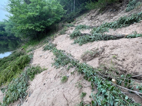
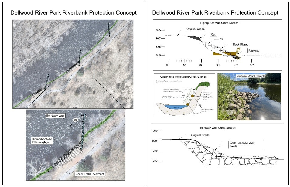
Supervisor Spotlight: Sharon LeMay

Sharon LeMay, who has been a Supervisor with ACD since January 2017, moved around a lot growing up, from England to Florida, France, Illinois, Texas, Minnesota, and back to England before finally settling permanently in Minnesota. She did not grow up in a family that spent a lot of time outdoors, preferring instead to visit museums, historic landmarks, and read. In fact, one of her first memories of nature was quite traumatic for her as a young girl. While exploring a vacant, wooded city lot, Sharon looked down at her tan corduroy pants and found they were crawling with little spiders, which she only learned later were actually wood ticks! Up to that point, her only experiences with nature involved manicured city parks or sightseeing in short trips. Still, even though recreating in nature was not a core part of Sharon's childhood, she grew up to revere nature and spend much of her free time working and volunteering to be a good steward of the environment.

When she isn't working, Sharon volunteers with several local organizations, including the Master Naturalist program, the MN DNR, and Herbalists Without Borders. She enjoys her studies in homeopathy and making herbal medicines. She also loves hiking, yoga, biking, visiting historic sites and museums, and camping with her husband and dogs.

Sharon's favorite place in Minnesota is the North Shore of Lake Superior. She loves the remote and rugged coastlines of oceans, and the North Shore is as close as it gets to that in Minnesota. She enjoys walking the beaches looking for stones, hearing the waves, smelling the air, or simply sitting on a rock watching the water. In this peaceful place, she is able to reflect on nature as something valuable in its own right, rather than valuable only for what we can do in it or with it. Her love for the environment evolved over time as she came to witness the sacredness of nature, and it culminated in her choice to run for elected office on the ACD Board of Supervisors. 

  960 Hits

Creating a More Resilient Landscape at Kings Island

Anoka Conservation District has been working with the City of Anoka and Mississippi Park Connection to create a more resilient landscape at Kings Island. Efforts have begun to remove invasive buckthorn from the island to allow space and light for native plant regeneration. Invasive emerald ash borer (EAB) infestations that kill ash trees have been detected throughout the Metro region and near Kings Island. Approximately 50% of Kings Island canopy is ash (green, black or white ash) so a loss of ash would have a great impact on the habitat on Kings Island. Surveys have and will continue to be conducted to monitor for the presence of EAB. To prepare for the loss of ash trees and create a more resilient landscape at Kings Island, a diversity of tree and shrubs were planted by volunteers. Species planted include Nannyberry (Viburnum lentago), Red-oiser Dogwood (Cornus sericea), Swamp white oak (Quercus bicolor), Butternut (Juglans cinerea), Cottonwood (Populus deltoids), Hackberry (Celtis occidentalis), Highbush Cranberry (Viburnum trilobum), and Sycamore (Platanus occidentalis) a tree with a more southern range. More efforts are needed to control buckthorn and create diversity for a more resilient landscape at Kings Island. 

  1108 Hits

Update - Riverbank Stabilization Project Construction in Mississippi River Community Park, Anoka

The riverbank stabilization project in Mississippi River Community Park is underway. Tree clearing, bank reshaping, and riprap installation have been the primary focus at this stage in the construction process.

Future work will include native seeding, erosion control blanket installation, and planting of native shrubs and trees.

The project is funded by a Clean Water Fund grant, a Watershed Based Funding grant, and match from the City of Anoka. Watch for more updates from ACD and the City of Anoka as the project progresses.

Read additional updates on our blog here and here.


UPDATE - October 2021

The riverbank stabilization project in Mississippi River Community Park is nearly complete. Tree clearing, bank reshaping, riprap installation, seeding, and erosion control blanket installation have all been completed. Planting of supplemental bare root shrubs, trees, and dormant live stakes will be completed by the end of November. The project stabilized approximately 1,500 linear feet of severely eroding riverbank.

  1017 Hits

Elected Officials Tour Water Management Projects

This month the Sunrise River Watershed Management Organization (SRWMO) hosted a public official's tour of water quality projects. The tour was to show cities who financially contribute to the SRWMO how their dollars are used. It was also an opportunity for multi-city discussion. Thirteen people were present including city council members, town board supervisors, a county commissioner, and SRWMO board members.

Tour visits included a stormwater pond enhancement, curb cut rain garden, lakeshore restoration, and infiltration basin. At three of the sites the owner was present to talk about the problems they had been experiencing and how the project has worked for them. Key information shared included costs, funding sources, and measurements of success.

The Anoka Conservation District (ACD) coordinated the tour. ACD is contracted to coordinate administration and projects for the SRWMO, which otherwise has no staff. The SRWMO and ACD have a 20+ year collaborative relationship that has resulted in dozens of water quality projects. The SRWMO is one of six watershed organizations that cover Anoka County.

Photos:

Top – Linwood Elementary School's principal and teachers describe a rain garden at their school entrance.

Middle – ACD staffer Jamie Schurbon describes how a stormwater pond at Martin Lake was enlarged to better capture pollutants form 24 acres of neighborhood.

Bottom – County Commissioner Jeff Reinert asks Coon Lakeshore owner Rhonda Scheiderich about a lakeshore stabilization and plant buffer (outside of image).

  889 Hits

Fall is a Great Time to Identify Invasive Species

Early fall can be a great time to identify invasive species around your property. Invasive species can potentially outcompete native plants. Controlling invasive species can help increase native plant diversity and create better habitat for local wildlife. It also help stop the spread of invasive seeds to your neighbor's property and other natural areas. The first step in managing invasive species on your property is by identifying them. Three species to look out for this time of the year are:

Canada Thistle is an aggressive perennial that produces many seeds. They are best identified by their wavy spiny/toothed margins that can be prickly if walked through. Most of their purple flowers have turned into a ball of white fluff by this time of year

Purple loosestrife is listed as a MDA prohibited noxious weed that grows along shoreland areas. Purple loosestrife can make it difficult to access open water and the dense root systems can even change the hydrology of wetlands. Leaves are lance-shaped with smooth edges and grow up to four inches long. They are usually arranged in pairs opposite each other on the stem, and rotated 90 degrees from the pair below. Individual flowers have five or six pink-purple petals surrounding small, yellow centers. Single flowers make up flower spikes, which can be up to one foot tall. This is a great time to look for the bright purple flowers along your shore.

Common tansy is also an invasive species that is currently flowering. The flowers are bright yellow and button like arranged in a flat-topped cluster. The leaves look fern like with reddish-brown stems. It is very common invasive species in the arrowhead of Minnesota. This quick spreading species can greatly impact landscape restoration efforts.

You can reach out to ACD if you want to confirm an invasive species on your property or want advice on how to manage the invasive population. 

  845 Hits

Pet Micro-chipping Technology In Carp!

Owners of loved and valuable pets sometimes have a microchip implanted to help recover them if they are lost or stolen. The same technology is now being used to help the Anoka Conservation District remove destructive carp from lakes.

We recently added microchip PIT tags to 187 carp in Typo Lake (Linwood Township). Those carp are now telling us when and proportionately how many carp are visiting baiting stations in the lake. An underwater sensor detects the carp when they are near the bait. A floating, solar-powered control unit uploads that data to the internet. This allows us to spring the nets around the bait at times that are likely to catch the most carp.

Graph: Number of PIT tagged carp visiting baited net stations over 7 days. Note the increase over time and the peak just after midnight. 

  1050 Hits

I Used to Mow There … and Now it’s Gone

"See that tree. I used to mow two passes between that tree and the shoreline. Now the tree is in the water." It's a common observation we hear from shoreland landowners. The erosion itself is slow enough that we can't see it immediately. But over time it becomes clear that erosion was happening all along. One measure of land lost is recalling how we used to use an area.

It's striking that the most common measure of erosion is "where we used to mow." Perhaps, it's part of the cause. As a general rule, many grasses have roots as deep as the plant is tall. That means mowed turf has 1-2" deep roots that afford little erosion protection.

As a simple way to slow shoreline erosion, consider an unmowed buffer at the water's edge. It's understood that this may not be feasible in dock, beach, or other active use areas. But in other areas, just let it grow or intentionally plant it with desirable native vegetation. ACD staff can help. Just give us a call.

  1021 Hits

Linwood Lakers Trying Out Native Shoreline Plants

"Try it, and you'll like it. The first one's free." A free trial can be just what's needed to break through to new customers. At this year's Linwood Lake Improvement Association annual picnic, the Anoka Conservation District distributed nearly 100 native shoreline plants to be planted all around the lake at around 20 different properties.

Native plants can mean "weeds" to some folks. Or just out of the comfort zone. But the right plant in the right place is beautiful and effective. On shorelines there are a variety of native plants that are the perfect choice –beautiful, strong, and well-adapted to the wet. Good habitat too. They're key to a stable shore and healthy lake.

Thanks to Prairie Restorations, Inc who provided the giveaway plants. ACD offers technical help and grants for those wanting to do a larger shore stabilization or buffer project. 

  1061 Hits

Riverbank Stabilization Project Construction to Begin in Mississippi River Community Park

The riverbank stabilization project in Mississippi River Community Park will begin this month. The current schedule forecasts project completion in early October and includes the general process outlined below.

  • Clearing and grubbing – Existing vegetation will be removed within areas that will be regraded to achieve a stable slope.
  • Erosion control – Protections will be put in place to prevent exposed soil from leaving the site during construction.
  • Excavation and riprap placement – This is the primary step in the stabilization process. The steep slopes will be regraded, and riprap will be placed at the bottom of the slope within the zone of frequent water level fluctuation.
  • Planting – The regraded slope above the riprap will be stabilized with native vegetation. Seed mixes, plant plugs, shrubs, and trees will all be planted.

The project is funded by a Clean Water Fund grant, a Watershed Based Funding grant, and match from the City of Anoka. Watch for more updates from ACD and the City of Anoka as the project progresses.

  986 Hits

Chloride Trends in the Rum River Watershed

The Metropolitan Council (MCES) put out a report on the trends of chloride in the Rum River Watershed. This report was based on data collected from 2001 to 2019 by both the MCES and Anoka Conservation District. Chloride concentrations have been rapidly rising in many waterbodies, including shallow aquifers, throughout Minnesota. This is a worrying trend because chloride is a permanent water pollutant that is toxic to fish, aquatic bugs, and amphibians. The main sources of chloride pollution in Minnesota comes from livestock excreta, household water softening, synthetic fertilizer, and de-icing salt. Chloride concentrations can be greatly affected by other factors like season, precipitation, and streamflow. During the winter months, concentrations rise with the use of approximately 400,000 tons of de-icing salt on Twin Cities' roads. Precipitation and streamflow also affect the concentration by dilution during high flow and precipitation years and concentration during low flow and precipitation years.

Luckily, the MCES found that concentrations of chloride are generally low in the Rum River. Chloride was increasing from 2001 to 2012 but has remained stable since 2012. Although this is a good sign, climate change is creating a wetter, warmer climate in Minnesota. This will greatly affect the freeze-thaw cycle and will have an unpredictable affect on pollution dynamics. Understanding how pollutants like chloride can affect Minnesota's waterways is an important step in keeping our waterways clean.
  947 Hits

Coon Lake Lakeshore Restoration – One Year Later

One year ago, ACD partnered with the Sunrise River WMO and a homeowner on Coon Lake to restore a damaged and degraded shoreline to improve water quality and lakeshore habitat, as well as promote native plant diversity and pollinator habitat. The shoreline was degraded by waves and ice, mowing of turf grass to the water's edge, and further damaged by tunneling muskrats. To correct these issues, the shoreline was regraded to a more gentle approach to the water, a muskrat deterrent was buried along the shoreline, and turf grass was replaced with native plants ranging from aquatic-emergent at the water's edge, to upland plants further up the bank.

The project was installed in July of 2020, and despite the recent drought, has flourished after one year of growth. Creating a diverse, native lakeshore can often be as simple as no longer mowing turf grass near the water's edge and planting native shoreline plants to create a more natural buffer area. The Anoka Conservation District can offer technical assistance to any landowner interested in creating a more beneficial shoreline, and oftentimes can bring financial assistance to a project as well. 

  1199 Hits

Restoring Hydrology and Wetland Habitat at Cedar Creek Conservation Area

The Anoka Conservation District, US Fish and Wildlife Service, and Anoka County Parks are collaborating to restore hydrology and enhance five acres of wetland and one acre of upland prairie at Anoka County Park's Cedar Creek Conservation Area. Two wetland basins were enhanced by installing sheet piling ditch plugs and adding fill material in a private ditch that was draining the wetlands. A berm to prevent water from entering the ditch was constructed to enhance a third wetland basin. Non-native reed canary grass biomass and root sod was scraped from these wetland basins and used to fill the ditch. Construction is complete and vegetation management will occur on these three basins and two additional basins in the area for the next five years using funds from the Lessard-Sams Outdoor Heritage Council. The goal is to convert these once drained wetlands that were dominated by reed canary grass to wetlands with native vegetation and greater water holding capacity. This will provide benefits to water quality and improve wildlife habitat.

  1350 Hits

Long Term Success of Cedar Tree Revetment Projects in Anoka County

Cedar tree revetments are a cost-effective bioengineering practice that can be used to stabilize actively eroding riverbanks. This spring, staff from the Army Corps of Engineers (USACE) visited several cedar revetment projects that ACD had installed between 2002 and 2016. The two staff from the USACE had been traveling to several states to review what is working and what is not working when it comes to cedar revetment projects. They are hoping to use the information to publish technical notes and/or peer reviewed literature.

They were very impressed by the effectiveness of ACD's revetments, even the very old ones. They attribute this effectiveness to the removal of the back branches. They had not seen this technique in any other state they had visited. Most cedar revetment failures studied, seemed to come from the trees moving/floating during high water and scour behind the trees causing more erosion. They also saw many trees that snapped in half, which was potentially from the stress of so much movement. They are planning to highlight the technique of removing the back branches in any published literature.

Almost all of ACD's revetments visited were still in place. Most had stopped, or greatly decreased erosion at the toe but did not fill in with sediment. The most common failure was broken wire that held the tree to the duckbill anchor. In most of these cases, the trees did not move a lot from where they were originally placed. The breakage seemed to be caused by rust.

  1211 Hits

Rum River Cedar Tree Revetments

The Anoka Conservation District has been working hard in partnership with Conservation Corp of MN and the Anoka County Parks Department to implement Cedar Revetments along the Rum River. So far nearly 1,500 linear feet along the Rum has been protected using the bio-engineered practice. These practices have been installed on private lands as well as property managed by Anoka County Parks. This type of practice is effective at protecting the bank from erosion while also enhancing shoreline habitat for wildlife. Cedar revetments are also much less expensive compared to other stabilization techniques. Through a state grant awarded to Anoka County Parks, there is currently funding available to cover 90% of the total project cost.

If you own property on the Rum River and are interested in protecting your shoreline, please contact Kris Larson for more information. 763-434-2030 x110, This email address is being protected from spambots. You need JavaScript enabled to view it..

  1188 Hits

Rain Gardens for Rice Creek

Street reconstruction projects often provide opportunities to install new projects that can benefit water quality in nearby waterbodies. In the City of Fridley, up to six curb-cut rain gardens are currently being designed in conjunction with a street reconstruction project. The designs are being done by ACD in partnership with the City of Fridley, the Rice Creek Watershed District, and landowners. The rain gardens will capture stormwater runoff before it enters the storm sewer system, which discharges to Rice Creek.

Depending on the underlying soils at each site, rain gardens with sandy soils will use infiltration (i.e. the water will soak into the ground) while those with finer soils (e.g. silty soils) will filter the runoff before discharging the cleaner water to the storm sewer system. In both cases, Rice Creek will benefit from reduced loading of sediment and nutrients.

High priority properties with large contributing drainage areas were targeted. Those properties with landowners willing to transition some yard space out near the road from turf grass to garden area and agree to provide maintenance are being considered for rain garden installation. Funding will be provided by the City of Fridley and the Rice Creek Watershed District.

Watch for additional updates as designs are finalized and the rain gardens are installed. To see other rain gardens already installed throughout Anoka County, please see the virtual project tour on ACD's website.

  952 Hits