Watch Out for Algae Blooms

Photo: Example of a harmful algal bloom

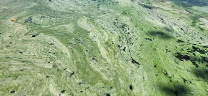
As summer warms up, the likelihood of harmful algae blooms increases. Cyanobacteria, also known as blue-green algae, are a type of photosynthetic bacteria. Cyanobacteria are naturally found in all lakes, rivers, and ponds, and, like plants and algae, they perform photosynthesis, obtaining their energy from the sun. Unlike true algae, cyanobacteria aren't a key part of the food chain, and most organisms choose not to eat them. Under the right circumstances, cyanobacteria can multiply to form a bloom. A bloom is a sudden increase in cyanobacterial cells in a specific area of water. Some species of cyanobacteria can create toxins that are harmful to human and animal health, known as cyanobacterial harmful algal blooms (cyanoHABs). 

Photo: Tips on tricks on harmful algal blooms

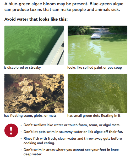
CyanoHABs can make people and animals sick if they breathe in, swallow, or come into contact with water or scum that contains toxins. Sunlight, high temperatures, and abundant nutrients, such as phosphorus and nitrogen, can increase the likelihood of a bloom occurring. Warm weather patterns and significant rain events that result in more stormwater runoff entering the water can also jump-start a bloom. Blooms typically occur during the warmer months, between mid-June and mid-September. As Minnesota's climate changes, it's fueling more frequent and intense rain events, floods, and warmer weather, contributing to more harmful algal blooms. For more information, check out the Minnesota Pollution Control Agency webpage or contact Kris Larson, Water Resource Specialist, at This email address is being protected from spambots. You need JavaScript enabled to view it.. 

  648 Hits

Two Animated Videos Added to the “Our Connection” Series

Our Watershed and Stormwater Connection

This video explains complex concepts about watersheds and stormwater in simple terms using engaging animation. It benefits all ages, from an elementary classroom to a city council chamber. Learn what watersheds are, why they are important, and some challenges watershed managers face. This ties into stormwater management and what public officials are doing to prevent flooding and improve water quality, as well as what we all can do to become part of the solution. https://youtu.be/pqdPe3Lvuao


Our Stormwater Pond Connection

Stormwater ponds are a common feature in many neighborhoods, and for many landowners, they are part of their backyard. This video uses simple terms and engaging animation to explain how stormwater ponds help keep our lakes and rivers clean. It also sets expectations for what is normal for your neighborhood stormwater pond, and perhaps more importantly, what not to expect. The video closes with practical advice on what to do to enhance stormwater ponds.   https://youtu.be/R80kXDOmyq0 

  987 Hits

Minnesota’s Buffer Law

Minnesota's Buffer Law was enacted to help keep Minnesota's water clean. Buffers are also known as a riparian filter strip adjacent to a stream, river, lake, or wetland. These buffers filter out phosphorus, nitrogen, and sediment. Studies completed by the Minnesota Pollution Control Agency show that buffers are critical to protecting and restoring water quality, natural stream functions, and aquatic habitat and life.

Buffers are required along public waterways and ditches. Public waterways include lakes, rivers, and streams. This type of waterway requires a 50-foot average buffer. Buffers of 16.5 feet are required along public ditches. The original buffer law was signed into law in 2015, and after several modifications, the deadline for implementation for public waterways was 2017 and 2018 for public ditches.

Buffers are required to be vegetated with perennials. This includes hay and forage crops such as alfalfa and clover, woody vegetation, perennial grains that can be harvested later, and prairie vegetation. This vegetation is key to helping keep Minnesota's water clean. Since 2017, soil and water conservation districts, including ACD, have worked hard to help bring all applicable parcels into compliance. The map below shows this hard work and that most of Minnesota are 94% to 100% compliant. For more information please contact Mollie Annen, This email address is being protected from spambots. You need JavaScript enabled to view it., 763-434-2030 x180

  2258 Hits

History and Management of the Rum River

Anoka Dam, October 1897

The Rum River is one of the largest rivers in Anoka County, second only to the mighty Mississippi. It starts at the outlet of Mille Lacs Lake and winds through the landscapes of Mille Lacs, Isanti, and Anoka Counties until it discharges to the Mississippi River in the City of Anoka—but many don't know about the progress this river has made to become one of Minnesota's most outstanding waterways.

To really appreciate the Rum River today, it's good to understand a bit of its history. For many decades, the Rum River served as a large scale aquatic conveyor for lumber. Large white pine, elm, oak, cherry, and maple all floated down the river from central Minnesota forests to build the homes and business of the growing Twin Cities Metro Area. It also conveyed our sewage, agricultural waste, sediment laden runoff, and industrial by-products downstream to the Mississippi River, and eventually the Gulf of Mexico.

A former Anoka County commissioner who grew up in the area once said that when he was a kid, no one would dare to even fish in the Rum River, much less swim in it. I'm happy to say, over the last 80 years, the fate of the Rum River has been wholly reversed. Today the Rum River is:

Martin's Landing on the Rum River
  • One of 6 Wild and Scenic Rivers and 35 State Water Trails in Minnesota
  • Designated as an Outstanding Resource Value Water
  • An excellent fishery and waterfowl corridor with abundant smallmouth bass and wood duck
  • Key reach for Species in Greatest Conservation Need

This isn't to say that our Rum River is in the clear. In the last 30 years, the population in the area draining to the Rum River has increased by 47%. With that many people came more roads, parking lots, and roof tops that added 74% more stormwater runoff. The increased water volume and speed that came with this extra stormwater caused the river to slice deeper into the landscape and rip apart the riverbanks. When riverbanks collapse into the river, the resulting sediment smothers the fish, amphibians, and reptiles that now call the river home. The Rum River is also increasingly threatened by road salt and nutrient pollution coming from this stormwater.

A Cedar Tree Revetment installed to stabilize a bank on the Rum River.

ACD takes a holistic approach to managing these new challenges to the quality of the Rum River. We are heavily involved with monitoring the chemistry and biological quality of the River; we assist the local Watershed Management Organizations with analysis and planning; and we implement projects with willing landowners to improve water quality and habitat in the river. ACD is also involved with guiding land conservation projects near the Rum River needed to protect habitat and water quality, and we are working diligently with other local organizations to ensure future funding for projects protecting the Rum River.

Over the coming months, we will be posting short blogs to highlight individual projects and programs that ACD has directed for the benefit of the Rum River. Check in soon at www.anokaswcd.org/blog to learn more!

  9177 Hits