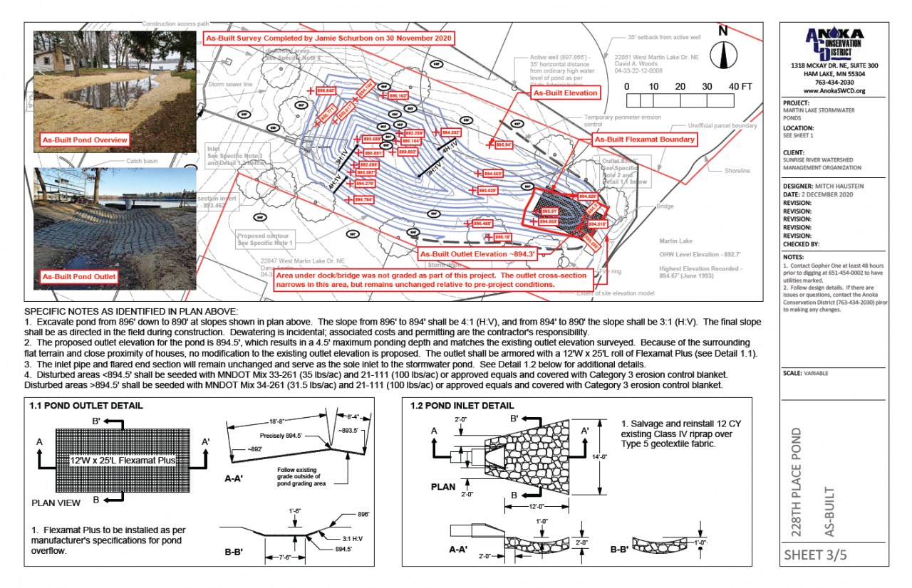
ACD Partnering with City of Anoka for Mississippi Riverbank Stabilization

Approximately 1,500 linear feet of eroding riverbank within Mississippi River Community Park in Anoka will be stabilized in 2021. The project is currently in the early stages of design and focuses on a stretch of severely eroding riverbank that was documented in an erosion inventory completed by ACD.

Eroding river banks contribute to the Mississippi River's sediment and turbidity impairments through direct loading of sediment and nutrients that degrade overall water quality as well as aquatic and nearshore habitat. Stabilization of actively eroding riverbanks is one of the most cost-effective practices to improve water quality because 100% of the sediment reaches the waterway.

Stabilization techniques will include bioengineering with native vegetation and a rock armored bottom of slope to stabilize the riverbank. The project will reduce pollutants by 529 tons of sediment and 847 pounds of phosphorus annually. Other benefits include aquatic life diversity and abundance, and improved drinking water quality because the project site is immediately upstream of drinking water intakes for the Twin Cities.

This project will also showcase river stewardship and enhance public recreation. Mississippi River Community Park and adjacent Anoka-owned King's Island include 1.7 miles of Mississippi River trail, 0.78 miles of riverfront, 0.91 miles of oxbow channel, pedestrian access to the island, sporting fields, public duck and deer hunting, and a fishing dock. This project will make over ¼ mile of unsafe riverbank more accessible, stable, and fishable for users. By naturalizing the riparian zone, this project complements the Mississippi River Corridor Critical Area rules.

The project is funded by a Clean Water Fund grant, a Watershed Based Funding grant, and match from the City of Anoka. Watch for more updates from ACD and the City of Anoka as the project progresses.

  2036 Hits

Mississippi Riverbank Stabilization Project Complete

The previously highlighted riverbank stabilization project on the Mississippi River in Ramsey has been completed. The residential property has 100 linear feet of riverbank that was nearly vertical and approximately 25' tall. Severe erosion was causing large portions of the bank to collapse and enter the river every year. The soil associated with those bank failures introduced significant volumes of sediment and nutrients into the river that contributed to water quality degradation. Stabilization of this severely eroding riverbank reduces annual sediment loading to the river by an estimated 224,000 lbs and total phosphorus loading by an estimated 112 lbs.

Project elements included clearing and grubbing of the few trees remaining on the steep slope, grading, riprap at the bottom of the slope, a reinforced soil slope (RSS) above the riprap to the top of the bank, native seed and plants, and erosion control blankets. The RSS consists of a honeycomb-like grid that is anchored to the slope and enables the finished slope to be steeper (e.g. 1.5 horizontal : 1 vertical), which maximizes the preservation of existing trees at the top of the slope.

Project funding is provided by a Clean Water Fund grant and landowner match.

  2762 Hits

Mississippi Riverbank Stabilization Construction Underway

Stabilization of a riverbank on the Mississippi River in Ramsey has begun. The residential property has 100 linear feet of riverbank that is nearly vertical and approximately 25' tall. Severe erosion was causing large portions of the bank to collapse and enter the river every year. The soil associated with those bank failures introduced significant volumes of sediment and nutrients into the river that contribute to water quality degradation. Stabilization of this severely eroding riverbank will reduce annual sediment loading to the river by an estimated 224,000 lbs and total phosphorus loading by an estimated 112 lbs.

Project elements include clearing and grubbing of the few trees remaining on the steep slope, grading, riprap at the bottom of the slope, a reinforced soil slope (RSS) above the riprap to the top of the bank, native seed and plants, and erosion control blankets. The RSS consists of a honeycomb-like grid that is anchored to the slope and enables the finished slope to be steeper (e.g. 1.5 horizontal : 1 vertical), which maximizes the preservation of existing trees at the top of the slope.

The project is on schedule to be completed by early October. Project funding is provided by a Clean Water Fund grant and landowner match.
  2958 Hits

Know Your Shoreline

If you live on water, whether it be a lake, river, creek, or stormwater pond, low water during the summer months can provide a great opportunity for you to conduct a quick inspection of your shoreline condition. The very bottom of your shoreline, where it meets the water, is called the toe and is the most critical part for stability.

Low water often exposes the toe of the slope and allows you to identify areas of concern. For example, you might observe undercutting, where the lowest portion of the bank has been scoured away by flowing water or wave action. When problems are caught early, the solutions are often much simpler and cheaper. Addressing erosion concerns early also helps prevent more severe bank failures down the road.

Another good time to inspect your bank is in the fall once leaves have fallen and before snowfall. You can inspect the upper portions of your bank for problems like rutting from concentrated overland flow over the top of the bank.

If you have any questions about your shoreline or think a site visit may be warranted, please contact ACD staff. We're here to help. 

  2102 Hits

ACD Staff Provide Virtual Tour for Metropolitan Area Conservation Districts Summer Meeting

Anoka Conservation District staff provided a 90-minute virtual tour focused on lake management and shoreline stewardship for the Metropolitan Area Conservation Districts summer meeting. Attendees included supervisors and staff from the 11-county metro area.

Typically, a bus tour is coordinated in order to highlight completed projects throughout the selected county. COVID-19 of course prevented this approach, but rather than cancel the tour, ACD facilitated a virtual tour. The novel approach was very well received by the approximately 30 attendees.

Topics included understanding your lake, assessing the health of lakes, recruiting and being a lake steward, and highlights of lake stewardship projects. Staff presentations used animations, pictures, and videos to demonstrate the complexity of managing different types of lakes and working with landowners to manage shorelines.

For more information about technical and financial resources available for lakeshore restoration projects, click here: https://www.anokaswcd.org/lakeshore-restoration.html/

  2143 Hits