Buffer Law Continues Making Headway

Nearly a decade after Minnesota's buffer law was enacted in 2015, 99.8% of parcels adjacent to Minnesota waters are in compliance with the law. Buffers are also known as a riparian filter strip adjacent to a stream, river, lake, or wetland. These buffers filter out phosphorus, nitrogen, and sediment. Studies completed by the Minnesota Pollution Control Agency show that buffers are important for protecting and restoring water quality, natural stream functions, and aquatic habitat and life. Buffers are required along public waterways and ditches. Public waterways include lakes, rivers, and streams. This type of waterway requires a 50-foot average buffer. Buffers of 16.5 feet are required along public ditches. 

Photo: This map reflects buffer law compliance rates across Minnesota's 87 counties.

ACD was proud to announce that Anoka County was 100% compliance back in fall, 2020. This milestone was achieved through strong partnerships between Anoka County, ACD, local landowners, and BWSR. This achievement doesn't mean that the hard work is over but it does represent a great success and displays the impact that strong environmental policy can have across the state of Minnesota. The next phase, includes another ACD review of properties throughout Anoka County to identify non-compliant parcels. This review began in Spring, 2024 and is based on recently released aerial photos. Compliance status and progress is tracked using the Buffer Compliance and Tracking Tool (BuffCAT), a state developed GIS database and mapping system.

Transfers in property ownership and land management changes, will require ongoing efforts by ACD in order to maintain existing compliance and to bring other parcels into compliance. Many landowners with noncompliant parcels have plans in place to seed the sites, or to implement an alternative conservation practice that provides comparable water-quality benefits this spring. Visit the ACD website to learn more about Buffer law implementation or contact Kris Larson, Water Resource Specialist, at This email address is being protected from spambots. You need JavaScript enabled to view it.

  113 Hits

Agricultural Lunch & Learn

  563 Hits

Funding Available For Agricultural Practices

The Anoka Conservation District is offering incentive grants to agricultural producers who use land management practices that benefit water quality and soil health. Eligible agricultural practices include cover crops, no-till, strip-till, conservation-tillage, prescribed grazing, nutrient management, and others. Available funding varies by the type of practice. A three-year commitment is required by the landowner to qualify for the program. 

For more information about this great opportunity, contact Jamie Schurbon at 763-434-2030 ext. 210 or This email address is being protected from spambots. You need JavaScript enabled to view it..


  593 Hits

Minnesota's Changing Climate

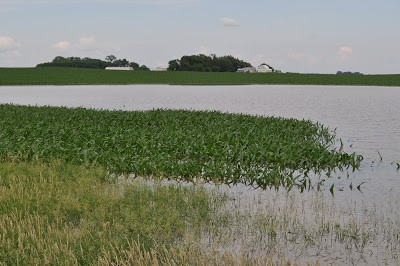
Flooding in a Southwestern MN Ag. Field

Minnesota is one of the states most impacted by climate change. Official precipitation and temperature data has been collected in Minnesota from 1895 through today, showing some striking statistics about our changing climate:

  • 13% increase in the size of the heaviest annual rainfall.
  • Since 2000, rains of more than 6" are four times more frequent than the previous 30 years prior.
  • 65% increase in the number of 3" rains.
  • Average temperatures in Minnesota have warmed by 3˚F since 1895.
  • Overall, Minnesota's climate is warmer and wetter.


These changes are impacting Minnesota's wildlife, forests, water quality, infrastructure, and outdoor recreation (especially winter sports). Below are some links to MN DNR infographic GIFs that shows the change to our 30-year average winter temperature and 30-year average yearly precipitation:


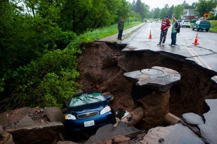
Sinkhole in Duluth Following a 7"+ Rainfall
As you can see, Minnesota's winters are warming dramatically, with the 9˚ contour moving  north by as much as 150 miles. Similarly, the 26" contour for precipitation has migrated roughly 100 miles to the Northwest.

We witnessed the impact of elevated precipitation in 2012 when the most damaging flood in Duluth's recorded history began when heavy rains fell over already saturated ground on June 19th and 20th. At the Duluth National Weather Service (NWS) the rainfall total for those two days was 7.24 inches. A NWS volunteer observer in Two Harbors recorded the storm's largest value of 10.45 inches in 24 hours.

The aftermath included millions of dollars of insurance losses to repair roads, bridges, homes and businesses. Many homes foundations were damaged extensively and the houses were razed. One state highway (MN 23) was closed for 3 years while it was repaired. The City of Duluth has had to adapt their stormwater infrastructure to withstand events that 30 years ago were considered 500-year events, but now happen regularly. In June 2018, just southeast of Duluth, the area received up to 10" of rain and once again damaged Highway 23.

Here in Anoka County, we've witnessed a similar story in 2019, with all of the monitored lakes, rivers, and streams in the County reaching historic water level averages for the year. This increase in precipitation only solidifies the need for comprehensive watershed management to make sure that our infrastructure and waterways can handle the increased erosion and flow produced by this additional rain. 

 Interested in learning more? Check out MN Pollution Control Agency's Climate Change in Minnesota webpage or the MN Department of Natural Resources Climate Data

  3480 Hits